2D, 3D, game, games, online game, game development, game engine, programming, OpenGL, Open AI, math, graphics, design, graphic, graphics, game development, game engine, programming, web development, web art, web graphic, arts, tutorial, tutorials,
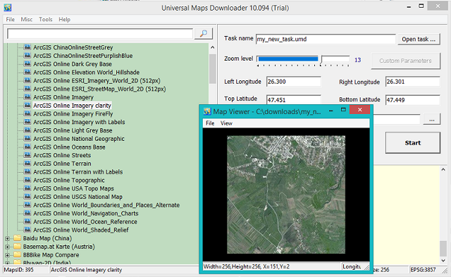
This tool named Universal Maps Downloader has been released at Jun 4, 2022 with the version number 10.094.
You can get small tile images from online maps like:
Alpenkarte.eu, Arcgis Online, Baidu Map (China), Basemap.at Karte (Austria), BBBike Map Compare, Bhuvan-2D (India), Bing Maps (Virtual earth), CalTopo, Carte-Geoportail, CARTO Basemaps, Chartbundle Chart (United States), CoCoRaHS Maps, Custom Map Type, Cyberjapandata.gsi.go.jp, Data.shom.fr, David Rumsey Historical Map Collection, Discover GIS Data NY (NewYork, United States), Ditu.so.com (China), Dituhui.com (China), Eniro(kartor.eniro.se), Epsg.io map, FINN Kart, Freemap Slovakia, Gaode Map (www.amap.com China), Geoportal PH (Philippines), Getlost Maps Live (Australia), Gisro.donland.ru, Globeland30.org , GoMap.Az (Azerbaijan), Google Maps, Gps.tile.openstreetmap.org, GraphHopper Maps, Here Maps, Inageoportal Peta, Jawg Maps, Kakaomap - Daum Map (South Korea), Kartat.kapsi.fi (Finland), Kartverket.no (Norway), Kort-krak.dk, Kort.lmi.is (Iceland), LA County (Los Angeles, United States), Lantmateriets Fjallkarta (Swedish), Latlon.org (Belarus), Location SA Map Viewer (South Australia), Longdo Map (Thailand), MAA-AMET (Estonia), Map of cities of UAE - 2GIS, Map Warper - mapwarper.onki.fi, Map Warper - mapwarper.prov.vic.gov.au, Map Warper - warper.wmflabs.org, Map Warper - www.mapwarper.net, Map.geoq.cn (China), Map.land.gov.ua (Ukraine), Map.meta.ua, Map.turistautak.hu, MapAnt (Finland), Mapas.bogota.gov.co (Colombia), Mapbox, MapFan (Japan), Mapmyindia Maps (India), Mappy.com, MapQuest Map, Maps of Switzerland, Maps-for-free.com, Maps.eatlas.org.au (Australia), Maps.lagosstate.gov.ng, Maps.lt (Lithuania), Maps.marshruty.ru, Maps.nlsc.gov.tw (Chinese), Maps.nlsc.gov.tw (English), Maps.randmcnally.com, Maps.refuges.info, Maps.stamen.com, MapSite (NLS of Finland), Mapy.cz, Mapzs.pzs.si (Slovenia), Mierune map (Japan), Min Karta (Sweden), MinView (Australia), Moovit, MOSCOWMAP (Russia), MTBmap.cz, MTBmap.no, MyGeoMap (Malaysia), Nakarte.me, Napr Maps (Georgia), NASA GIBS, National Library of Scotland (maps.nls.uk), National Map (Australia), Naver Map (South Korea), Navitel.Maps, Navizor, New Zealand Gazetteer, New Zealand Topographic Maps, NL Maps (Netherlands), North Carolina Maps (US), Nostra Map (Thailand), NZ Topo Map, Omniscale, Onemap (Singapore), Online Outdoor Hiking Bicycle MTB Map, OpenAIP map, OpenFireMap, OpenRailwayMap, OpenSeaMap, OpenSnowMap, OpenStreetMap, OpenTopoMap.ru (Russia), OSM deutscher Stil, Osm.rrze.fau.de, Osm.rrze.fau.de HD, Osmand.net, Osmdata.asitvd.ch, PDOK Viewer (Netherland), PhilaGeoHistory Maps (Philadelphia, PA, US), Photon.komoot.io, Portland Maps (Portland, United States), Publictransportmap.org, Reit-und Wanderkarte, Retromap.ru, Roscosmos Geoportal, S2maps.eu, SafeCast Map, ScanEx Web Geomixer, Sentinel-2 map, Shipxy.com, Skoterleder.org, Sogou map (China), Solargis.com, Stadia Maps, Strava Global Heatmap, Survey of India Maps (India), Sverige karta, Tencent Map (China), The National Map (United States), Thunderforest, Tianditu (China), Topomapviewer.ngi.be, Topotresc, Toronto Maps (Canada), UMP-PC.pl, ViaMichelin, Vietbando Maps (Vietnam), Visicom Maps (Ukraine), VWorld 2D Map (South Korea), Wanderservice-schwarzwald.de, Waymarkedtrails.org, Waze Livemap, Whereis Maps of Australia, Wikimapia, Wikimedia Maps, World Imagery Wayback, Www.ign.es (Spain), Www.kompass.de, Yahoo Japan Maps, Yahoo Maps, Yandex Maps (Russia), Custom Map Styles of Bing Maps, Customized Google Maps, Custom Map Type, etc.
You can view downloaded maps by Maps Viewer Or you can combine them into a BMP/TIFF/JPG/PNG/ECW/SIG/IMG/KMZ/RST/PNM file by Maps Combiner, and also you can export all tiles into a MBTiles format database.
This is a video tutorial from youtube channel CGBit.
Because I like well-built things with good interfaces and good graphics, I present a very useful project for people to live together in a healthy society.
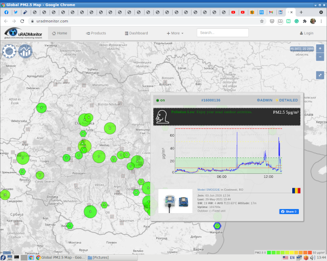
The uRADMonitor project provide a good map with many features and good design.
Hackaday Prize Semifinalist in 2014, the uRADMonitor Model A is a digital radiation dosimeter unit with a network interface to centralise the data online. It uses a Geiger Muller tube to sense the ionising radiation, and uses very little power to run. It comes in a rugged aluminium enclosure and can be installed outdoors, if mounted in vertical position, thanks to a rubber gasket that makes it rainproof.
There are several hundreds of such units distributed worldwide, in what has become World's first global Radiation Monitoring network. from hackaday.io project.
Looking at our planet and its environment
For the ultimate benefit of all European citizens...
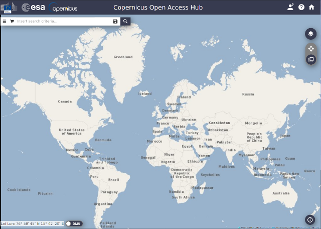
The Open Access Hub provides complete, free and open access to Sentinel-1, Sentinel-2, Sentinel-3 and Sentinel-5P user products... Copernicus builds on a constellation of satellites making millions an impressive number of daily observations, as well as on a global network of thousands of land-, air- and marine-based sensors to create the most detailed pictures of Earth. The technological evolution, especially in terms of availability and accessibility, has made Copernicus the largest space data provider in the world, currently producing 12 terabytes per day. The vast majority of data and information delivered by the Copernicus Space infrastructure and the Copernicus services are made available and accessible to any citizen and any organization around the world on a free, full and open access basis. You can access Copernicus Data and Information Services through the DIAS or the Conventional Data Hubs...
See this online tool scihub.copernicus.eu with data and maps from satellites...
Fresh high-resolution terrain across the United States was added to Cesium World Terrain. New 3m terrain now covers large sections of the United States, including major cities such as San Francisco, Washington DC, Portland, Seattle, Salt Lake City, Philadelphia, Raleigh, and New Orleans, to name just a few. The quarry near San Francisco shown below highlights how the new high-resolution terrain (left) brings the hills, roads, and steps into focus. Try the slider to see how the new terrain also better matches the high-resolution imagery. New 0.5m terrain now covers the entire West Coast of the US, from the Mexico border all the way up to the Canada border. This coastal shot shows the old terrain (right); the rugged nature of the coast becomes clear with new high resolution terrain (left).
This website come with this great tool for aerial photographs to millions of satellite images of the Earth’s surface into great archive from 1937.
They tell us: The U.S. Geological Survey's (USGS) Long Term Archive (LTA) at the National Center for Earth Resource Observations and Science (EROS) in Sioux Falls, SD is one of the largest civilian remote sensing data archives. It contains a comprehensive record of the Earth's changing land surface. Scientists from around the world depend on this archive to conduct research on changes that affect our environment, resources, health, and safety. Time series images are a valuable resource for scientists, disaster managers, engineers, educators, and the general public. USGS EROS has archived, managed, and preserved land remote sensing data for more than 35 years and is a leader in preserving land remote sensing imagery. USGS EROS has a mandate to provide access and data preservation support for its land remote sensing data archive.
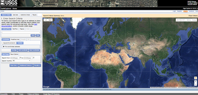
The tool simple to use just select your area from Search Criteria - use the points lat/long and the use the Data Set(s) to select by your options.
You can use more than one data set to search into your area and the result will be show like a log.
This online tool can be found here.
This is a screenshot with this online tool:
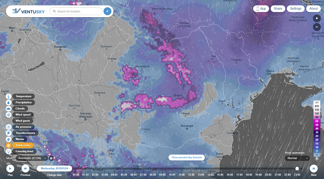
This website come with a good weather features and application and with a great graphics and design.
The Ventusky application to your mobile phone or tablet come with faster data loading, better-arranged control and more detailed forecasts.
See the next screenshot of Ventusky webpage:
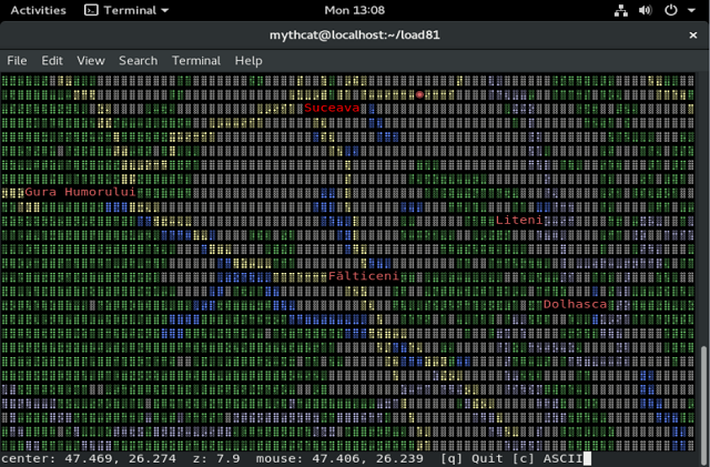
The MapSCII use telnet to show you whole world into your console.
The project can be found here.
To test it just run this telnet command with your linux or use PuTTY on Windows:
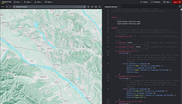
Tangram is an open-source map renderer designed to animated shaders, 3D buildings, and dynamic filtering can be combined to produce effects normally seen only in science fiction.
The Tangram Play is an interactive text editor for creating maps using Mapzen’s Tangram rendering engine.
Also, you can write and edit map styles and preview the changes live in the web browser.
This unitypackage let you to use some maps features like: Maps and location data optimized for Unity. Written from the ground up in C#, the Mapbox Unity SDK unlocks global data to generate custom 3D worlds, power location lookup, and incorporate traffic-based directions in your next Unity project.
You can download this unitypackage from mapbox.com.
Let's test with Unity ( version 5.6.0f3 Personal ) .
First you need to download it and then you need to import it into your project.
Import package in Unity from the Unity editor menu: Assets - Import package - Custom Package or use double-click on downloaded mapbox-unity-sdk_v0.5.1-beta.unitypackage.
Take an API token is required to access Mapbox services.
Use your token from here into Unity project.
Use click Mapbox - Configure Access from the Unity Editor menu and then paste your token into the Token field. Assuming your token is valid.
This SDK is pretty and complex, but you can find examples with the installation of this packet and so try and modify it until you get used to it.
Here's a screenshot of a few minutes of testing and testing with this SDK.